The Last Gap Between Asphalt and Canopy
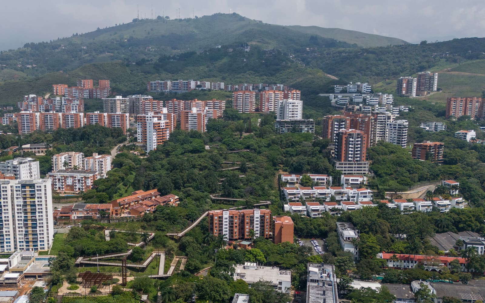
In cities that sprawl against mountain ranges, the transition zone between built fabric and protected wilderness often becomes a contested edge: too steep for conventional development, too degraded for ecological function, and too fragmented to serve either realm well. Edward Conde Serna Arquitectos confronted precisely this condition in Cali, Colombia, where the final undeveloped strip between urban neighborhoods and the Cristo Rey Ecopark had become a liability rather than an asset. Completed in 2024, the Cali Foothills Integral Corridor reimagines this 57,000-square-meter threshold as landscape infrastructure, a deliberate intervention designed to restore ecological continuity while creating new public ground.
The project's ambition extends beyond park-making. By establishing what the studio terms an "urban forest," the corridor positions itself as the first link in a longer chain connecting the dense urban core to the Farallones de Cali National Natural Park, a biodiverse highland reserve. In doing so, it acknowledges that cities and protected areas cannot function as isolated islands; they require connective tissue, corridors that permit species movement, hydrological flow, and thermal regulation across scales.
Landscape as Infrastructure, Not Ornament
At World Archi Design, we've observed a recurring pattern in Latin American urbanism: the tendency to treat green space as decorative rather than structural. The Cali Foothills Integral Corridor resists that impulse. Its design framework prioritizes ecological performance, watershed management, and habitat restoration as foundational moves, not aesthetic afterthoughts. The corridor's topography, steeply graded and erosion-prone, demanded a tectonic approach that stabilizes soil while accommodating public access.
The studio deployed a vocabulary familiar to contemporary landscape urbanism: permeable surfaces, bioswales, native plantings organized in successional layers, and pedestrian circulation that follows contour lines rather than fighting them. These strategies are not novel in isolation, but their integration here reflects a maturity of practice. The design avoids the grandstanding gestures common to competition-winning parks, opting instead for a quieter, more systemic logic. Paths meander to slow stormwater runoff; retaining walls double as seating; planting zones are calibrated to microclimate and soil moisture rather than visual symmetry.
This is infrastructure that reads as landscape, a deliberate blurring of categories that recalls the work of Hargreaves Associates in post-industrial sites or the ecological urbanism advocated by firms like Turenscape in China. The difference here lies in scale and context: Cali's corridor is neither a brownfield reclamation nor a riverfront promenade, but a hillside edge condition where the primary challenge is continuity, not transformation.
Restoring Continuity Across Fragmented Systems
Ecological corridors succeed or fail based on their ability to permit movement, not just of people but of water, seeds, pollinators, and fauna. The Cali Foothills project addresses this through a series of linked interventions. Native tree species, selected for their ability to thrive in Cali's tropical dry forest climate, form the structural backbone. These plantings are not ornamental; they are calculated to create canopy cover, reduce surface temperatures, and provide habitat for birds and insects that facilitate seed dispersal between the urban forest and the higher-elevation reserves.
The corridor also functions as a critical buffer for the Cristo Rey Ecopark, a popular but ecologically stressed zone that has suffered from informal trails, soil compaction, and invasive species. By concentrating public programming and circulation within the lower corridor, the design reduces pressure on more sensitive upslope habitats. This is a form of strategic redirection: offering compelling civic space to absorb recreational demand while allowing degraded areas time to regenerate.
Hydrologically, the corridor intercepts runoff from adjacent neighborhoods before it can erode hillside slopes or carry sediment and pollutants into downstream watersheds. Bioswales and retention basins slow water velocity, promote infiltration, and filter contaminants. These elements are integrated into the pedestrian experience, visible rather than buried, a pedagogical move that makes stormwater management legible to the public.
A Collaborative Design Process
Edward Conde Serna Arquitectos assembled a notably large team for this project, involving more than two dozen designers, technical consultants, and landscape specialists. The lead team, directed by Jorge Alexis Viveros, coordinated input from disciplines ranging from civil engineering to botany. This collaborative structure is worth noting: landscape infrastructure of this complexity cannot be authored by a single hand. It requires negotiation between ecological science, engineering feasibility, and spatial design.
The design team included Jorge Salazar Marcillo, Karol Vega, Diana Quiros, Jorge Armando Guzmán, Andrés Felipe Sanchez, Arley Duvan Mesa, Juan Esteban Sandoval, Dalia Lucía Peña, Daniel Henandez, Daniel Jácome, Victor Gutierrez, Nathalia Cruces, Juan Galvis, Juan José Bello, Nicolas Zambrano, Juan Pablo Rondón, and Santiago Torres. The technical team, responsible for grading, drainage, and structural systems, comprised Marisol Ceballos, Daniela Molina, Angie Ordoñez, Adrián Saavedra, Carolina Reina, Hernan Viracachá, Javier Fajardo, Carlos Puerta, and Ricardo Mercado.
This roster suggests a studio culture that values distributed expertise over singular authorship, a model increasingly common in landscape and infrastructure projects where the stakes are as much ecological as architectural. The corridor's success will ultimately be measured not in awards or publications, but in canopy density ten years hence, in measurable reductions in erosion, in the return of species absent from the urban edge.
Precedents and Departures
The Cali Foothills Integral Corridor invites comparison to other hillside interventions in Latin American cities. Medellín's series of escalators and park connectors, designed to link informal settlements to the urban core, prioritized social equity and mobility. Bogotá's Parque Tercer Milenio reclaimed a degraded urban quarter, though its focus was remediation rather than ecological continuity. The Cali project shares DNA with both but leans more heavily toward landscape ecology than social infrastructure.
Globally, the corridor aligns with projects like Singapore's Southern Ridges, a network of elevated walkways and reforested hillsides that connect urban parks across varied topographies. Both projects recognize that green space in dense cities must be networked, not atomized. But where Singapore's interventions are highly engineered and visitor-focused, Cali's corridor adopts a lower-tech, more incremental approach, allowing natural succession to do much of the work.
Measuring Success Over Time
One of the most challenging aspects of landscape infrastructure is temporal scale. Buildings are assessed upon completion; landscapes require decades to mature. The Cali Foothills Integral Corridor, opened in 2024, is effectively a seedling. Its tree plantings are saplings; its soil stabilization systems are untested by the full force of rainy season deluges; its role as an ecological corridor remains theoretical until fauna begin using it as a migratory route.
This temporal dimension demands a different evaluative lens. The project's immediate contribution is spatial and civic: it provides Cali with a new public realm in a city where green space is unevenly distributed. But its deeper ambition, to initiate the consolidation of an urban forest and restore connectivity between fragmented ecosystems, will unfold over years. Monitoring protocols, ideally involving local universities and environmental agencies, will be essential to track biodiversity indicators, canopy cover, stormwater performance, and public use patterns.
The corridor also sets a precedent for how Colombian cities might address similar edge conditions. Bogotá, Medellín, and other Andean cities face comparable challenges: rapid urbanization pressing against mountainous terrain, degraded hillsides, and the need to balance public access with ecological protection. If the Cali model proves replicable, it could inform a generation of hillside interventions across the region.
Design as Long-Term Commitment
What distinguishes the Cali Foothills Integral Corridor from more conventional park projects is its insistence on continuity, both spatial and temporal. It does not position itself as a finished object but as the beginning of a longer process, a framework within which natural systems can reassert themselves. This requires a different kind of design intelligence, one that understands when to intervene and when to step back, when to engineer and when to let succession take over.
Edward Conde Serna Arquitectos has produced a project that is deliberately understated, its ambitions embedded in grading plans, planting schedules, and hydrological calculations rather than in dramatic formal gestures. It is the kind of work that may not photograph as spectacularly as a Calatrava bridge or a Zaha Hadid cultural center, but it addresses a more fundamental urban challenge: how to repair the ecological damage wrought by decades of fragmented, uncoordinated growth.
In this sense, the corridor is less about architecture in the traditional sense and more about stewardship, a commitment to restoring systems that cities depend on but rarely acknowledge. For a discipline increasingly concerned with climate adaptation, biodiversity loss, and urban resilience, the Cali Foothills Integral Corridor offers a pragmatic, site-specific model. It reminds us that the most urgent work in contemporary practice may not be the construction of new icons, but the patient, incremental repair of the connective tissue between city and nature.
Save this story. A free account keeps your reading list and the 07:00 email in one place.
CREATE FREE ACCOUNT →SIGN IN